What exactly is the Basic ILS Point Cloud?
The Basic Information Delivery Specification Point Cloud (Basic ILS Point Cloud) was created to make 3D measurement data (as a point cloud) interchangeable, ordered, uniform, accurate, complete and reusable. This guideline builds on the already established foundations of the Building Information Model (BIM) Basic ILS.
What are point clouds?
Point clouds have been acquired for about 10 to 15 years by scanning with a 3d scanner or laser scanner. There are constantly new developments in this field, for example, since 2023 we have a dynamic scanner in addition to static scanners: a GEOslam, where SLAM stands for Simulteaous Localisation And Mapping.
Below is an example of an on-site photo with the Faro Focus scanner at a store and the image of the point cloud taken of that store. This scan was used to model and design the facade for a permit application and was scanned in color.
The video below is a flytrough of a point cloud from a movie theater. This point cloud was made to make a NEN 2580 measurement: for this reason, only black and white was scanned: indicating the contour is sufficient for the area measurement.
Why do we use the BIM Basis ILS Point Cloud?
The Basic ILS Point Cloud provides guidance for making good arrangements when requesting and delivering point clouds. In order for cooperation to run smoothly and not have problems in cooperation during the project, uniform agreements are important. In the overview below, the arguments for this:
- Purposes of information exchange: a point cloud of the existing situation can be created for several purposes. These purposes vary in their expected use and the methods and techniques employed for data acquisition, processing and delivery.
- Collection methods: practical and safe access to a site and understanding of exceptions are critical to proper planning and selection of collection methods.
- Use of information: to get a handle on the whole process, it is important that the acquiring party knows how the end user wants to use the information. This begins with an inventory of intended software packages.
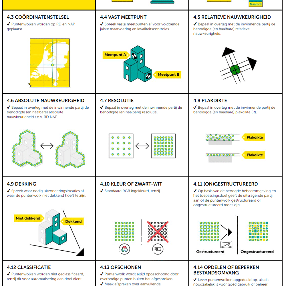
- Basic agreements: When surveying an existing situation, agreements are always needed on the following points:
- Exchange format: The exchange format should be suitable for the receiving application and preferably an open file format.
- File name: Agree in advance how file names will be worded so that files are easily distinguishable.
- Coordinate system: Point clouds are placed on the RD (National Triangulation System) and NAP (Normal Amsterdam Level).
- Fixed measurement point: Agree on fixed measurement points for sufficient correct sizing and quality control.
Relative accuracy: In consultation with the collecting party, determine the required (and achievable) relative accuracy.
Why is this important for quality?
By making the request concrete using our BasicILS checklist, we ensure that both the requesting party (client, consultants) and the supplying party (NewArmstrong or someone who scans and models point clouds) think carefully about how to scan and how to offer the point cloud.
Getting the expectation and execution right is essential: the trick is to “get it right the first time.
Measurement and delivery of point cloud as a separate assignment?
Measuring and providing a point cloud we do for our own projects that we design and model for. For other projects, we work with supplied point clouds or models.
However, the request to only scan and provide a point cloud is also possible. We have also made separate surveys for example NEN 2580 measurements of large buildings such as offices or shopping centers.
Conclusion
The Basic ILS Point Cloud provides a solid basis for structured and reliable exchange of 3D measurement data in the construction industry. NewArmstrong is a partner of the BIM Basic ILS and the Basic ILS Point Cloud. If you want a surveying where what is provided is agreed in advance and clearly agreed upon, ask for a surveying that complies with the Basic ILS Point Cloud.
Would you also like to use the benefits of digital surveying to the standard of the Basic ILS Point Cloud? If so, please contact us.


